I ran and finished la Grande Course des Templiers, a 70km trail run starting from Millau, Aveyron, France, with around 3000m of climb*. The last two years I tried a similar race, actually the old version of Les Templiers, run from neighboring Nant and now called Les Hospitaliers. But both times I abandoned after 45 km and around 7 hours. I decided that better preparation was required this year.
For the last couple of months I have been extending my regular 12km run around the Forêt de Meudon in the Paris suburbs to include more elevation. The regular run was an loop around the forest with a couple of 50m climbs from valley floor to the plateau. The modified version involved going up just about every possible track or trail and back down, turning it into a 500-600m+ total climb and something like 18km distance. I alternated this with my regular run, for 4-5 outings a week and threw in a couple of longer 30km-ish runs for good measure. What else? A minimal amount of track work (I am more or less obliged by the dog to run in the woods), a couple of bike outings with the club and a 10k race the week before Les Templiers. Oh and most important, I decided to make an effort and lose some weight. This worked well for the biking and also for the 10k (45m40s). So I was pretty keen to see how it all came together on the day.
Set off at 5:15 am in the dark with the field of around 2200. It was chilly, around freezing and there were some patches of very light snow on the ground and even a few flakes blowing in what turned out later to be a pretty strong breeze. From Millau we climbed up onto the Causse Noire and headed across country to the first refueling stop at Peyreleau, near the confluence of the Tarn and Jonte rivers. Some pretty country on the way down into Peyrleau but at this stage of the race, it was either too dark or maybe I wasn’t paying much attention to the scenery. The going was pretty easy too, with a good wide track up onto the Causse and rolling trails over to Peyrleau. This allowed the field to string out nicely without too much standing on each others toes before the ‘monotrace’ the single track that characterized most of the rest of the race. The field sorted itself out remarkably efficiently and in the later stages one really did not feel that overtaking or being overtook was either necessary too often nor particularly hard. Folks were polite and, at least at the rear end of the field where I soon ended up, did not seem to mind swapping places. You get a pretty good idea of what it was like from the VO2 video. From Peyreleau back up onto the Causse Noir and on to St André de Vezines, for another food break. Food was an interesting mixture of the usual sports drinks and energy bars and dried fruit, along with doorsteps of bread and cheese which I wolfed down. On from Saint André we passed through La Roque Sainte Marguerite where I was greatly encouraged by family and friends. There had been a question of me bailing out here, this was about as far as I had got the two previous years on the Hospitaliers. But I felt good, in fact I really felt that the race hadn’t started yet. I was right.
From La Roque things went quiet as we climbed at a steady, rather slow, walk in Indian file up a steep path that seemed to have been carved straight out of the mountain side the day before. The organizers like to find unusual new routes which sometime travel along paths which have not seen much recent use. They sure get used when the 2000 trailers have been through. Another face-stuffing exercise (with more bread, cheese and now soup) at Pierrefiche on the Plateau du Larzac, not far from the famous military camp whose extension in the 1970s sparked off a huge protest movement in France and which was one of the origins of the Green movement.
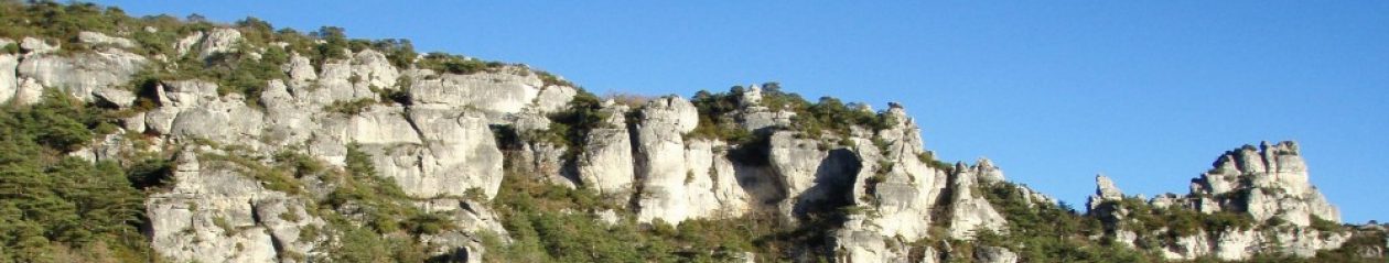
Like I said, things got a little more tricky on the Larzac. The notion of ‘plateau’ should not be conflated with ‘flat.’ The trail goes along the plateau edge of the Dourbie valley. It is almost all a monotrace and it goes up and down all the time. Having said that, this was also the start of the truly scenic part of the Templiers. It’s not that the Causse Noire, let alone the Tarn/Jonte valleys, aren’t spectacular, it’s just that the route that the Templiers takes is not a great way to see them. The path along the Larzac edge on the other hand, affords spectacular views across the Dourbie and onto the dolomitic ‘ruins’ of Montpellier le Vieux and the limestone climbing site at Le Boffi. Of course trotting along a monotrace does not really lend itself to taking in the scenery. I must go back and do this as a walk sometime.
When I say ‘trotting’ this is perhaps a bit of an exaggeration. Things were easy up to La Roque but the unremittingly tricky nature of the trail from then on meant that I slowed down considerably. I averaged 6kph up until La Roque (km 45) but only managed 5kph overall. Even the leaders passed the 34km half way point in around 2hrs 35 but finished spread over a 6hr10 to 6hr30 interval. Comprehensive statistics and more information are available on the Templiers home page.
I know the Dourbie valley rather well and was surprised at how long it was taking up to do what is quite a short distance. Things got even harder with the descent into the valley. Down more seemingly improvised tracks through mud fields, more twisty monotraces and just as you though it was all over, back up a sizable hummock before the final descent to Massabiau. This afforded a short respite in that, although the exit from the village is steep, it is on a paved road. But not for long.
The final section of the Templiers has to be experienced to be believed. Every time the path up to the Cade farm looked like it might be flattening out, blow me! the markers just went straight up the rocky hillside. Having fallen behind schedule somewhat, I quizzed a fellow traveler as to whether we were going top make it in time. ‘Pas de problème’ he offered before dropping back and sitting down on a rock in a rather final sort of a way. Further up to the Cade another runner intimated that we had better get a move on to avoid the cut off at Le Cade at 5:15pm (12 hours). This we made with 15 minutes to spare. More food. Soup and (finally) Roquefort cheese. After Cade I was concerned again as to finishing in time but learned to my relief that Cade was the last cut off and that you could take as long as you liked to do the final 8km. In fact it took me well over 2 hours. Some took over 3. The last 8 k involves going back down (almost) to the valley, then another 300m climb. The trail started through a pleasant, flattish forest trail which obliged one to gives one’s best shot at actually running. Some put up quite a good showing. Not sure how I looked myself, I was starting to feel my age.
Leaving the plateau for the penultimate time, evening fell and we witnessed a spectacular scene of a red sky backdrop to the fabulous Millau Viaduct. This was shortly replaced by a magnificent moon rising up to cast a ghostly pale on the white limestone of the Causse – well, kind of …
Going back up to the Puncho D’Agast paragliding launchpad, involved more scrambling. With nightfall, and my energy level a bit low, I found it quite hard to keep my balance. I recommend doing Les Templiers at the back of the peloton to experience the combined folly of rock climbing while running at night.
Finally we were off back down the last 400m vertical with more slippery stuff. I met up with a young lady who was doing all this with no headlight! So we shared the light from mine and the joint exercise took my mind off thoughts like ‘how much longer can this go on!’ A great treat on the way down is the trip through a substantial cave – the Grotte du Hibou which you can see at the end of this video, at 7min 30s although the earlier part gives you a good idea of the rugged terrain and how the leaders performed.
I was very pleased to finish and surprisingly, did not feel that there had been too much strain on the old body. Running the 70k trail is actually easier than a 42k marathon. Something to do with the variety of trail running and the difficulty of running ‘at speed’ for a marathon course. Anyhow what can I say? Thanks to the organizers, especially the many volunteers giving direction, encouragement, posting and picking up the signing after the event. Thumbs down to the (mercifully) few who jettisoned their stupid little tubes of go faster gunk on the parcours. And a big thumbs up and many thanks to family and friends for their support for what was a super weekend.
* The meters of climb, like the length of the British coastline as determined by Benoit Mandelbrot, depends on the length of your ruler. While the ‘official’ elevation is around 3000m, on the equally ‘official’ GPS trace of the run, if you use a 50m horizontal sample interval, you get a 3800m climb. You takes your pick. I wonder what the standard way of measuring elevation and distance of a trail run in rugged country is.